Thar she blows: Satellite captures images of erupting volcano in Russia
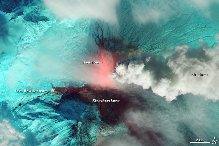
It may not be the first place that comes to mind when thinking of active volcanoes. But in a remote region of northeastern Russia, they're there. And they are erupting. Photos from NASA's Landsat 8 satellite are capturing amazing images of the explosive activity.
Slate calls the cluster of 150 volcanoes, located on the Kamchatka Peninsula, "among the most active on the planet."
The highest of these, at almost 16,000 feet, is Klyuchevskaya Sopka. The stratovolcano — which basically means a large, steep volcano made up of layers of lava and ash or cinders — has been spewing since the 1600s. The amazing images show the volcano emitting lava into the icy terrain.
There are up to 30 active volcanoes in the area, according to the website Volcano Discovery, allowing for plenty of light shows. In October, the NASA imagery captured volcanic eruptions of lava, ash and steam.
Molecular biologist Richard Roscoe, who lives in Munich, Germany, last month created a time-lapse video of two of the volcanoes giving an explosive show over a span of 20 hours. He does this for fun.
"Kamchatka is particularly interesting, as it has numerous volcanoes which may be active at any particular time," Roscoe told Yahoo Travel via email.
Roscoe admitted that volcano hunting is not a particularly safe hobby. "If the lava dome were to have a major collapse during the period of our visit, we would probably not have had much chance of survival in the area we were," he added.
Thankfully, we can see all the explosive drama safely from our screens.

